

Point of origin and destination
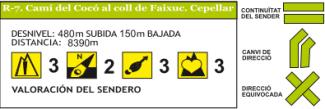
This route begins at the Casa Museo del Cocó and ends at the Coll de Faixuc, on Mount Cepellar, foothills of the Sierra de Bèrnia, on the municipal border with Altea. It can be done in the opposite direction.
Brief description
This route, which is signposted in light green, begins at the information panel of the traditional paths that is located at the back of the Casa Museo del Cocó. Looking at it, we will take the road to our left passing by the well of the house. We descend along the road and, after passing through the entrance of the Botanical Garden, at a fork of the road, we will take the one on the right. Soon we cross the Barranco del Pou Roig and continue, now in slight ascent, until the next fork in which we take the road on our left, until the Casa del Trosset del Recto. We crossed the Avda. Generalitat and continue the street in front by a street between houses where we enter. On leaving it we take the street on the right that ascends parallel to the small ravine that descends from the Oltà mountain range, next to the House of Benicuco. Before reaching the national road (N-332) there is a detour to the left that takes us through the same bed of the ravine and we take the asphalt road that ascends to our left, near there is a fork, which we take to our left, and a little higher we leave the asphalt and we take a path to the left that takes us to a crossroads, where we take the road to the left. We cross the road of the station and continue straight ahead until before a cave where we take an asphalted branch to the right that leads us to the national road. At this point, to the right, part of a road which we take takes us to a paved road. We continue to the right in the ascent, we pass under the bridge of the train, we climb a little and, before reaching a house, we take a path to the left, we pass by a well and then we ascend passing under an electric tower. We continue for the pine forest in direction south until arriving at another electric tower, we descend for a road until arriving at a group of houses (House of Bou). When passing the house on the right, in the same fence of the house, part a path that we continue in ascent until we reach a small hill. From here starts the Route R-8 that goes to the Castellet. We continue to our right until we reach a plain (old shooting range)we discard the track that ascends and we continue for the one that plains until we find the track that ascends and we continue for the one that plains until we find to our right an entrance of a road that ascends, we take it and, when we arrive to the upper part, we take a path to the left, we continue chattering and then we begin to descend, we pass by the street of the small house, we arrive to a wider road and, without continuing for him, now we take a path to the right that ascends in diagonal. We continue along the path until passing near the waste transfer plant, on our left, and the Casa dels Calvos, on the right. The road takes us to an asphalted road that we continue on the right, we cross the highway by the tunnel and, on the next fork, we take the paved road on the left that descends to the bed of the ravine (Barranc Salat). We continue from the front to the fenced gate, we pass by the right of the fence ascending next to it. We pass by the Casa de Bufes until we reach a flat area of pine forest. Soon after the path separates from the fence ascending up the hill to the Coll de Faixuc where we can see the bay of Altea.
Elements of interest
Old drinking water supply channel. Covered by a section of the old road of Altea. Gypsum geological formations. Old gypsum firing furnace. Micro reserve area. Cave Mine.